By John Estridge
With the development of Whitewater Memorial State Park and then the Brookville Lake, Union County lost 9,606 productive acres off the tax rolls, according to Union County commissioners.
Not only do Union and Franklin counties not receive any tax money from the acres made into parks, the former with property purchased by the state and the other by the federal government, but they often see their respective expenses increase due to the influx of visitors and other factors. The Brookville Lake/Whitewater Memorial State Park Complex is the most-visited park in the state’s inventory.
Almost annually commissioners and council members from several different counties, that host state parks, lobby for a new law that would require DNR to give a certain amount, per paying visitor, and send that to the host county to offset the amount of property tax loss and the increased costs that come from visitors.
Those bills never make it out of the DNR Committee to get a vote from the entire legislature.
Thus, those are some of the facts that tend to make commissioners from both counties upset, especially when there is a problem apparently caused by DNR properties, and it negatively affects the counties’ residents, and the state seems reluctant to spend money to fix the problem.
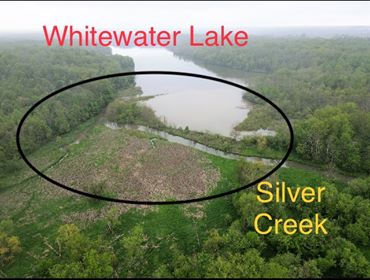
Case in point is the flooding of properties near where Silver Creek feeds into Whitewater Lake. The properties are off Snake Hill Road/Huntington Road and where the road intersects CR 125 and on toward the lake.
Commissioner Tim Williams discussed the situation near the end of Friday morning’s July 10 commissioners’ meeting.
Silt is filling in Whitewater Lake, Williams and commissioner Howard Curry said. In the past, the Indiana Department of Natural Resources dredged the lake to keep the silting under control. Recently, a drone with a good camera was flown over Silver Creek, Williams said.
Where Silver Creek empties into the lake is now a delta with weak fingerlings for the creek’s output. In the past, the water was in one stream and actually dropped to the lake. However, the state discontinued the dredging program at some time in the past. There is no elevation change now, the commissioners said.
Land around where Silver Creek runs into the lake has become a marshland, commissioners said.
Add to that the ash borer nemesis and wind storms, and the ash trees and other fallen trees have made mini dams along the creek.
According to Curry, one of the huge log jams is on the state’s property.
And the creek is silting in along many sites up and down the creek, they said. Thus, if there is a hard rain, the water in Silver Creek backs up onto privately owned property along the creek and the county road. This especially affects those who live near where Silver Creek meets the lake; they are having to contend with several floods every year, commissioners said.
In the past, flooding was a rarity, the commissioners said.
“It’s never been an issue until recent years, water going into Whitewater Lake,” Curry said. “It used to be it took a catastrophic flood to make it back up to the owners’ properties (and) to our (county) road. Now, any kind of rain is making it back up. They quit dredging the lake so, instead of running the water into a hole, you’re running water into a flood plain.”
“There’s a big problem there,” Williams said. “Not only what’s going on with the state not taking care of their property … I met with DNR in one of those Zoom meetings. The first thing out of their (DNR officials’) mouth was ‘that’s going to be expensive to fix.’
“And you (DNR) used to do it (dredge), but you stopped doing it,” Williams continued on what he told DNR officials at the Zoom meeting. “Now we have a county road flooding and people’s houses flooding.
“And they said ‘we’re not sure that’s the problem,’” Williams continued.
Curry said the drone footage flown by a local resident showed a sandy swamp, and the resident told Curry the sandy swamp was a cornfield 12 years ago.
Williams said a resident’s barn had 18 inches of water in it while her finished basement had four.
Curry said his next statement may not be spot on with the numbers, but it is close.
“In the last 35 years prior to the last five years, it happened twice,” Curry said. “And it’s happened every year in the last five years. It’s the same time they quit dredging the lake.”
According to Williams, the DNR official said they are going to fly a drone along the area, and it will check on the level of the land to see how much the silting has affected the creek and surrounding areas.
“They did that about five years ago,” Williams said. “They are going to see what all switched.”
Williams brought up a previous meeting that both Williams and the DNR official attended concerning the latest bill that failed in the legislature.
“You know I’m upset there’s a large swell of land we get no tax dollars for, but you have the No. 1 most-visited park in the state,” Williams said.
The DNR official acknowledged he remembered the meeting.
“How mad do you think I am that you’re not taking care of the property you are getting for free?” Williams asked.
The reply was prolonged silence, Williams said.